Edmonton has released a new mobile app called SmartTravel. The new mobile app issues verbal safety warnings to Edmonton drivers. You can get live warnings as you drive or before. Interesting idea.
Edmonton has released a new mobile app called SmartTravel. The new mobile app issues verbal safety warnings to Edmonton drivers. You can get live warnings as you drive or before. Interesting idea.
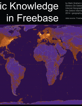
Thanks to a note from Domenico Fiormonte to Humanist I came across the Information Geographies page at the Oxford Internet Institute. The OII has been producing interesting maps that show aspects of the internet. The one pictured above shows the distribution of Geographic Knowledge in Freebase. Given the importance of Freebase to Google’s Knowledge Graph it is important to understand the bias of its information to certain locations.
Geographic content in Freebase is largely clustered in certain regions of the world. The United States accounts for over 45% of the overall number of place names in the collection, despite covering about 2% of the Earth, less than 7% of the land surface, and less than 5% of the world population, and about 10% of Internet users. This results in a US density of one Freebase place name for every 1500 people, and far more place names referring to Massachusetts than referring to China.
Domenico Fiormonte’s email to Humanist (Humanist Discussion Group, Vol. 29, No. 824) argues that “It is our responsibility to preserve cultural diversity, and even relatively small players can make a difference by building more inclusive ‘representations’.” He argues that we need to be open about the cultural and linguistic biases of the tools and databases we build.
From a New Scientist article I learned about Traсes. Traces lets you leave a bundle of information (like a song and some greetings) for someone at a particular GPS location (and at a particular time.) You can thus use it to add gifts for other people to find. It strikes me a neat use of augmented reality. I can imagine all sorts of uses for it beyond gifts:
Alas, it is not available in the Canadian App Store.

The New York Public Library has another cool digital project called the Building Inspector. They are crowdsourcing the training and correction of a building recognition tool that is combing through old maps. You see a portion of a map with red dots outlining a building and you click “Yes” (if the outline is correct), “No” (if it is wrong), and “Fix” (if it is close, but needs to be fixed.)
They also have a neat subtitle to the project, “Kill Time. Make History.”
At the inaugural Edmonton Pipelines meeting I’ve learned a lot about different spatial projects. Some include:
The Edmonton Pipelines project is SSHRC funded. They are interested in community engagement which is why they organized the inaugural meeting and invited researchers in the city doing work with geography. They chose the name “pipelines” to play with the idea of how data is changed over space. They have a number of subprojects including one on Queer Edmonton that I am interested in as we are working with Pipelines on a locative game that exposes people to the queer history of Edmonton.